


Remontéée Tarn

jpipacific
User
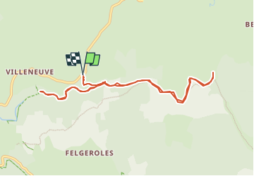

Length
10.2 km

Max alt
1329 m

Uphill gradient
208 m
Km-Effort
12.9 km

Min alt
1150 m

Downhill gradient
208 m
Boucle
Yes
Creation date :
2022-08-06 15:15:21.993
Updated on :
2022-08-06 15:23:17.05
2h00
Difficulty : Easy

FREE GPS app for hiking
 SityTrail
IGN / Geographical institutes
SityTrail Plus
The world is yours!
About
Trail On foot of 10.2 km to be discovered at Occitania, Lozère, Pont de Montvert - Sud Mont Lozère. This trail is proposed by jpipacific.
Description
A faire Uniquement tracée sur carte
Positioning
Country:
France
Region :
Occitania
Department/Province :
Lozère
Municipality :
Pont de Montvert - Sud Mont Lozère
Location:
Le Pont-de-Montvert
Start:(Dec)
Start:(UTM)
562974 ; 4913637 (31T) N.
Comments